Need a severe weather event covered? Contact me for further details.
Follow me on my social media accounts below!
Monday 9th May 2016
 |  |
|---|---|
 |  |
 |  |
 |  |
 | 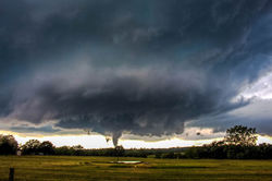 |
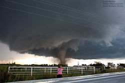
Well what a day this was, certainly a day I will NEVER forget. We started the day in Oklahoma City and the SPC (Storm Prediction Center) had upgraded to an enhanced risk of severe weather across the region. Our target area for the day was down around Pauls Valley, which is about an hour or so south of Oklahoma City. With great moisture, very steep lapse rates, strong instability along a dryline and warmfront and with impressive shear values in the 50-70 kt range and turning with height, supercells capable of very large hail, damaging wind gusts and a few tornadoes with one or two potentially to be intense were expected.
However what would develop on this day would be a spectacle not many could of predicted. A storm went up just to our south west as we watch this storm pulse several times until finally it got it's act together and matured into a supercell, very quickly from here it developed into a tornadic beast as it dropped what would now take over the number 1 ranking for all of my tornadoes, and EF4 monster near the little towns of Katie - Wynnewood Oklahoma. This monster crossed the road just a few hundred metres in front of us and the roar was like being up close to Niagara Falls!!!! After this tornado dissipated we maneuvered into position to catch a glimpse of a mile wide wedge tornado as it moved quickly east. Once we pulled up to see our second tornado I looked across the road further to the east to be shocked at seeing yet another violent EF3 tornado. What an incredible chase day this was, one that will take a lot of beating!!