Need a severe weather event covered? Contact me for further details.
Follow me on my social media accounts below!
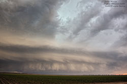
Sunday 22nd November 2015
 |  |  |
|---|---|---|
 |  |  |
 |  |  |
 |  |  |
 |  |  |
 |  |
Sunday 22nd November 2015.
Models had agreed on a southerly change that had pushed through the SE Coast of Queensland would be funneled back into the Darling Downs region (known as a Ridge Cradled Trough or RTC). With an approaching upper trough, strong instability would develop across southern inland regions of QLD. Excellent shear with a strong LLJ was expected to move in across the afternoon with supercell thunderstorms likely to develop.
By mid afternoon our first supercell took shape just north of Inglewood which produced beautiful mothership looking storm stucture. We were treated to some close cg's while the storm moved into a roadless region. Meanwhile just off to our west the beast of the day was developing and would spin its head off for hours while moving in a north easterly direction. When we got into position to intercept this storm near Millmerran we were greeted to stunning HP structure with cloud to ground lightning strikes every few seconds. We chased this storm for around 4 hours while it cycled on numerous occasions. Finally on dusk this storm began to weaken and slowly die, what an incredible storm this was. One of the highlights for the 2015/2016 storm season!
Saturday 28th November 2015


Saturday the 28th of November 2015 would be a fantastic day for storm chasing. Another Ridge Cradled Trough (RCT) would set up over the Darling Downs with a sharpening dryline. Strong instability and excellent wind shear was in place for explosive supercell development during the late afternoon.
Sitting east of Dalby, we watched as towers went in the dry air west of the dryline, however they would quickly die off. Finally a cluster of towers that were strong enough moved east, crossed into the rich moisture and rapidly exploded. Strong inflow soon accompanied this developing storm as it began to rotate into a supercell.
This storm took on classic supercell characteristics with an impressive wall cloud developing and a strong rear flank downdraft (RFD). We encountered anvil hail around the 3-4cm mark, and were not surprised to find out later that hail the size of cricket balls fell in the town of Oakey.
Sunday 29th November 2015


A surface trough and upper trough moving through South East Queensland during the late afternoon and evening would be the catalyst for severe thunderstorm development. Conditions were ripe across the region for organised activity.
Initiation occurred over the eastern Darling Downs during the early afternoon before storms outflowed to the east. Mid afternoon an updraft develop across the Scenic Rim area and quickly developed into a mature thunderstorm. One of the most fascinating things that occurred at this time was that the storm developed near a controlled burn off and was sucking the smoke vertically straight into the developing updraft. Soon after, this storm developed supercell characteristics and marched quickly to the north-east with Brisbane in its sights. It was soon labelled a VDS (very dangerous thunderstorm) by the Bureau of Meteorology. We encountered hail to golf ball size near Archerfield, winds to 90km/h and some very impressive storm structure.
This continued what had been an activity 2 week period with quality thunderstorm set ups.